Beureukaih:Indonesia, administrative divisions - en - monochrome.svg

Ukuran pratayang PNG ini dari berkas SVG ini: 800 × 367 piksel Resolusi la'én: 320 × 147 piksel | 640 × 293 piksel | 1.024 × 469 piksel | 1.280 × 587 piksel | 2.560 × 1.173 piksel | 982 × 450 piksel.
Beureukaih aseuli (Beureukah SVG, nominal 982 x 450 piksel, rayek beureukah: 909 KB)
| Hareutoë |
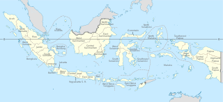
English: Indonesia provinces map (in Malgache)
Français : Carte des provinces indonésiennes (en malgache) Deutsch: Karte der indonesischen Provinzen Malagasy : Saritanin'ny faritany indonezianina (amin'ny fiteny malagasy) |
||||
| Uroë buleuën | (UTC) | ||||
| Asai | |||||
| Ureuëng peugöt |
|
||||
| Versi lainnya |
|
||||
| SVG genesis | W3C-tidak sah Gambar vektor ini dibuat menggunakan Inkscape.
|


beureukaih nyoe geulisènsi ngön lisènsi Creative Commons Attribution-Share Alike 3.0 Unported.
- Droeneuh geubri idin keu:
- ngui sajan – seumalén, seumipreuek ngön pumeuét buet
- peugöt ulang – ngui keulayi gamba
- Meunurôt syarat di yup nyoe:
- atribusi – Droeneuh peureulèe neutuléh asai karya nyoe lagèe nyang geupeuteuntèe lé ureueng tuléh atawa ureueng po hak (tapi kön ngön meukeusud keuneuk promosi karya ureueng nyan).
- weuëk saban – Apabila Anda menggubah, mengubah, atau membuat turunan dari materi ini, Anda harus menyebarluaskan kontribusi Anda di bawah lisensi yang sama seperti lisensi pada materi asli.
Log pengunggahan asli
This image is a derivative work of the following images:
- File:Indonesia, administrative divisions - mg - monochrome.svg licensed with Cc-by-sa-3.0,2.5,2.0,1.0, GFDL
- 2010-02-04T05:32:46Z Queix 1322x620 (326516 Bytes) Modifying of foreign area's castline
- 2010-02-03T18:37:53Z Queix 1322x620 (325080 Bytes) {{Information |Description={{en|1=Indonesia provinces map (in French)}} {{fr|1=Carte des provinces indonésiennes (en français)}} |Source=*[[:File:Indonesia_provinces_map-fr.svg|]] |Date=2010-02-03 18:34 (UTC) |Author=*[[:Fi
- 2010-02-02T21:42:13Z Queix 1322x620 (319665 Bytes) '
- 2010-02-02T21:32:37Z Queix 1322x620 (319755 Bytes) '
- 2010-02-02T21:29:23Z Queix 1322x620 (319852 Bytes) '
- 2010-02-02T18:56:04Z Queix 1322x620 (319689 Bytes) {{Information |Description={{en|1=Indonesia provinces map (in Malgache)}} {{fr|1= Carte des provinces indonésiennes (en malgache)}} |Source=Travail personnel (own work) |Author=Sardon |Date=02/02/2010 |Permission= |other_ver
- File:Indonesia_provinces_english.png licensed with Cc-by-2.5, Cc-by-sa-3.0-migrated, GFDL
- 2006-01-08T07:54:20Z Golbez 1500x590 (78783 Bytes) Map of the provinces of Indonesian in English. Made by [[User:Golbez]] based on a PD CIA map, using other sources to guesstimate the extent of West Irian Jaya and West Sulawesi. [[Category:Maps of Indonesia]]
Uploaded with derivativeFX
Riwayat beureukaih
Neuteugon bak uroe buleuen/watèe keu neu-eu beureukaih nyoe ‘oh watèe nyan.
| Uroe buleuen/Watèe | Beuntuk ubeut | Dimènsi | Ureueng ngui | Beunalaih | |
|---|---|---|---|---|---|
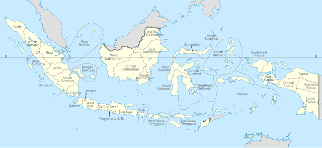
| jinoë hat | 4 Buleuen Duwa Blah 2022 23.09 | | 982 × 450 (909 KB) | NordNordWest | adding Southwest Papua |
| 21 Buleuen Lapan 2022 10.03 |  | 982 × 450 (737 KB) | Afrogindahood | Addition of new provinces in Western New Guinea | |
| 24 Buleuen Tujôh 2022 16.04 |  | 982 × 450 (954 KB) | Qexypnos | Reverted to version as of 21:38, 14 August 2021 (UTC) | |
| 23 Buleuen Tujôh 2022 03.43 |  | 2.560 × 1.170 (824 KB) | Qexypnos | map correction | |
| 23 Buleuen Tujôh 2022 03.34 |  | 2.560 × 1.170 (824 KB) | Qexypnos | added provinces of Highland Papua, South Papua, Central Papua | |
| 15 Buleuen Lapan 2021 04.38 |  | 982 × 450 (954 KB) | Afrogindahood | Minor resolution readjustment | |
| 22 Buleuen Siplôh 2020 20.47 |  | 786 × 360 (731 KB) | Afrogindahood | Addition of North Kalimantan province | |
| 21 Buleuen Sa 2011 20.48 |  | 1.322 × 620 (318 KB) | Yug | Font size | |
| 21 Buleuen Sa 2011 20.33 |  | 1.322 × 620 (319 KB) | Yug | bug fix trial 4 | |
| 21 Buleuen Sa 2011 20.30 |  | 1.322 × 620 (319 KB) | Yug | buf fix trial 3 |
Seuneungui beureukaih
laman di yup nyoe mupawôt u beureukaih nyoe:
Neungui beureukaih global
Wiki laén di yup nyoe geungui beureukaih nyoe:
- Seuneungui bak an.wikipedia.org
- Seuneungui bak ar.wikipedia.org
- Seuneungui bak ban.wikipedia.org
- Seuneungui bak bbc.wikipedia.org
- Seuneungui bak bg.wikipedia.org
- Seuneungui bak bn.wikipedia.org
- Seuneungui bak bs.wikipedia.org
- Seuneungui bak cs.wikipedia.org
- Seuneungui bak en.wikipedia.org
- Seuneungui bak frp.wikipedia.org
- Seuneungui bak he.wikipedia.org
- Seuneungui bak id.wikipedia.org
- Seuneungui bak id.wikibooks.org
- Seuneungui bak ja.wikipedia.org
- Seuneungui bak lt.wikipedia.org
- Seuneungui bak mg.wikipedia.org
- Seuneungui bak pt.wikipedia.org
- Seuneungui bak ro.wikipedia.org
- Seuneungui bak simple.wikipedia.org
- Seuneungui bak sq.wikipedia.org
- Seuneungui bak tl.wikipedia.org
- Seuneungui bak tr.wikipedia.org
- Seuneungui bak uk.wikipedia.org
- Seuneungui bak vec.wikipedia.org
- Seuneungui bak vi.wikipedia.org
- Seuneungui bak zh.wikipedia.org